Posts tagged carbon cycle

Digging out from the storm

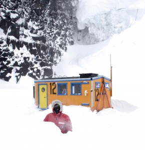
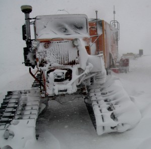
Our Sno-cat tucker gets drifted in

Our Sno-cat tucker gets drifted in (Photo AN)

The next day offered more snow and wind: we still needed handheld radios anytime we ventured between the warming hut and any of the vehicles. The wind was so strong that snow began drifting up through the dive hole in the warming hut, and the windows completely glazed over with snow. At one point Abigail ventured out with her camera, so follow this link if you want to experience a condition 1 Antarctic storm from the safety and comfort of your chair. Needless to say trips outside were kept to a minimum, and we were sure to keep hot chocolate and coffee at hand.

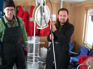
Mak and Jeff prepare to lower a sediment trap

Mak and Jeff lower the sediment trap (Photo DM)

So even though it was a day stuck indoors, there was plenty of science to do, and we considered it an incredible stroke of good luck to be stuck in a hut with a convenient access hole to the Ross Sea! Dawn was able to pull some plankton from the sea ice and view them in the ambient light of one of the windows. Abigail’s focus of research is metal chemistry in the marine environment, and she was able to do some prep work, soaking and treating all of her Nansen Bottles to remove any traces of contaminating metals. Metal concentrations in seawater are notoriously difficult to quantify as all of the tools we use are contaminated with metals, including the plastic bottles and lines used to deploy them. Soaking them in seawater for 24 hours will mitigate the problem, so we lowered them below the sea ice.

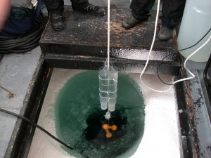
Deploying the sediment trap below the ice

Deploying the sediment trap (Photo DM)

Mak Saito also brought his custom-made sediment trap, and this too was deployed for a 48 hour incubation below the ice. Sediment traps are particularly important tools in oceanography, as they help scientists quantify the flow, or flux, of dead and dying plankton from the sruface to the ocean depths. As plankton sink, they are effectively removing organic carbon and nutrients from the ocean surface, so understanding this rate has important implications for the speed at which carbon is removed from the atmosphere and sequestered in the ocean depths.

It also turned out that the dive hole was not a one way street: throughout the day Weddell seals would use the hole in the ice as an access point for air. Weddell seals are master divers, and they can dive up to 700 m (2100 ft) deep, and they can stay underwater for over an hour as they search for fish, squid and krill. When they would pop up in our dive hut, they seemed very keen for air, and they would spend a full minute hyperventilating to clear the carbon dioxide out of their lungs before disappearing back below the ice.

Dawn shoveling a path to the mobile lab

Dawn carving a path through the drifts to our mobile lab (Photo MS)

Eventually the storm slowed down enough that we could start to dig ourselves out. There was still snow blowing down off of the Erebus glaciers, but by our third day in the hut, visibility started to improve enough that we could shovel path and clear vehicles. Dawn and Abigail cleared a path to our lab sled while Mak, Jeff and I cleared away the generator and transferred fuel to the Pisten Bully. I was also able to use the Iridium satellite phone to get a call out to my wife, who is currently in Bukhara, Uzbekistan: making a call from a fish hut in Anarctica to a 14th century silk road city is a really mind-bending use of technology!

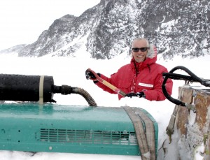
Digging out our generatos so that we can charge up the Pisten Bully (Photo MS)

Digging out our generator so that we can charge up the Pisten Bully (Photo MS)

The Pisten Bully needed to be warmed for two hours before we could start it up, but once it was running we decided to head back to McMurdo while the weather was good. We has GPS coordinates to get us back to the Cape Evans sea ice road, and from there it was relatively easy to follow the flags back to McMurdo Station. On Monday we will head back out, and so hopefully our next post will be from station one. Until then — keep warm!

Back on Land

We arrive in Ft. Lauderdale and are all glad to be back on land for a few days. But we were also elated by the success of the first part of the expedition. This first journey was difficult because we had to deploy and test new equipment, to sample a diverse array of environments and oceanographic features, from large surface and subsurface blooms of photosynthetic organisms to nutrient-depleted areas of the Caribbean, and it was the first time in a year that the Sorcerer II had really been tested in open water and long distances. Data on both photosynthesis and respiration were captured, much of which will be novel and highly useful in explaining the metabolic pathways and biological participants involved in carbon and nutrient cycling in the ocean.

This week we prepare to depart for Bermuda and the Azores and will continue on to Plymouth Marine Laboratory in England. Based on the sampling success of the first leg of our journey, it is difficult to contain our enthusiasm over the microbial discoveries that lay ahead. Stay tuned as we share more scientific adventures with you.

Sampling Blooms in Cabo Corrientes

Just south of Puerto Vallarta is Cabo Corrientes, and our satellite data indicate a large bloom extending 25 miles off the coast. As we enter the bloom the water turns an intense green, and there are numerous fish feeding in the area. Sampling conditions are ideal: bright sunshine, light winds, moderate swell. We deploy a large plankton net which rapidly fills with algae and zooplankton. Karen McNish looks at the larger diatoms and zooplankton under the scope while the rest of the crew prepares our instrumentation for deployment.

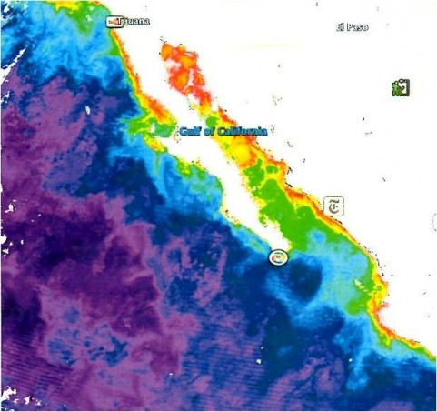
Satellite image of phytoplankton blooms along the Mexican coastline, March 2009.  The Ilsa Cedros bloom is halfway down the Baja peninsula on the west side, the Cabo Corrientes bloom is the red area in the lower right corner of the image.

Satellite image of phytoplankton blooms along the Mexican coastline, March 2009. The Ilsa Cedros bloom is halfway down the Baja peninsula on the west side, the Cabo Corrientes bloom is the red area in the lower right corner of the image.

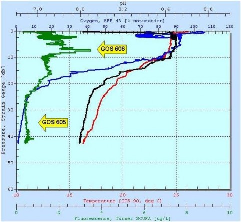
The CTD profile of the water column at Cabo Corrientes showing a surface phytoplankton bloom.

The CTD profile of the water column at Cabo Corrientes showing a surface phytoplankton bloom.

From the aft cockpit we deploy a CTD equipped with a sampling hose. A standard CTD measures conductivity, temperature and depth: our unit also contained a pH probe and a fluorometer for measuring chlorophyll concentration. As we lower the CTD through the water column, we generate a profile of the ocean at Cabo Corrientes down to 40 meters in depth. At left you can see the CTD plot: depth is plotted on the y-axis as a change in pressure, and pH (black) and temperature (red) are plotted on the top two x-axes, with oxygen (blue) and fluorescence (green) plotted on the bottom two x-axes. In this case, the peak fluorescence (green trace) is at 8 meters in depth, and after that, the concentration of oxygen (blue trace) falls from 90% saturated to 5% saturated. The peak fluorescence indicates the location of the chlorophyll max (or Chlmax), where most of the photosynthetic plankton are located, and the oxygen minimum (or O2 min) indicates an area of intense respiration immediately under the Chlmax. Both of these areas contain a wealth of undescribed microorganisms, and understanding the relationship between photosynthesis and respiration in the ocean is one of the keys to understanding the global carbon cycle. We took samples at 8 meters and at 35 meters before continuing our southward trip.